Westshore, Napier
Coastal Protection
Why Westshore is one of Napier's least flood-exposed neighbourhoods — and the plan to restore its beach.
Many associate coastal living with the dangers of flooding and inundation; not the case for Westshore.
Flood modelling
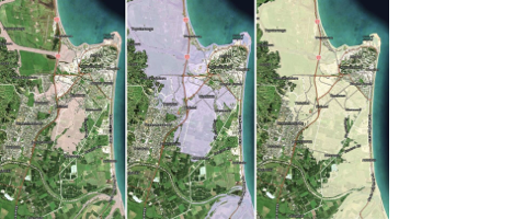
These flood modelling maps compare the impact of current sea levels (left), a 0.5m sea-level rise (centre), and a 1m sea-level rise (right). Produced by NIWA (now Earth Sciences New Zealand), they illustrate the areas that could be affected by a 1-in-100-year coastal flood (interactive versions are available on the Hawke's Bay Regional Council and Napier City Council websites).
These maps show that Westshore is significantly less vulnerable to coastal flooding than many other parts of Napier, primarily because of its natural elevation.
Westshore: sits on a spit between 3–4 metres above mean sea level.
Much of central Napier and surrounding low-lying areas: as low as minus 2m below mean sea level.
While many homes, businesses and transport routes across Napier face increasing coastal flood risk, Westshore's elevated position provides a substantial natural advantage, resulting in significantly lower flood exposure as modelled here.
Beach Restoration
For generations, Westshore was renowned as one of Napier's favourite swimming and recreational beaches. Over the past 40 years, however, the beach has gradually eroded, changing the character of this much-loved coastline.
Today, Westshore has been identified as a strategically important location for protecting the lower-lying land behind it. Because of this, plans are now being developed to halt further erosion which will also restore the beach to the wide, sandy recreational coastline it once was.
The restoration will not only strengthen Napier's coastal resilience but also create a major asset for residents and visitors alike—bringing back a beach where future generations can once again swim, walk, relax and enjoy everything that makes Westshore such a special place.